OreScanner - Early-Stage Mineral Exploration Diagnostics
OreScanner is a desktop, satellite-based exploration diagnostic designed to support early-stage mineral targeting. It applies structured spectral analysis to screen large areas of interest and prioritise surface anomaly zones for follow-up consideration before committing field resources.
How it Works
OreScanner applies a proprietary computational workflow to multispectral satellite imagery data. Diagnostic spectral indices relevant to surface mineral alteration signatures are computed and evaluated spatially across the area of interest.
A number of indices are computed and weightings are applied depending on the target element. Results are normalised and aggregated to the 1x1 km2 grid cells to emphasise spatial coherence and reduce sensitivity to isolated pixel responses or noise.
Outputs & Deliverables

Technical PDF report
Concise tailored report summarising analysis method, key outputs, and recommended next steps.
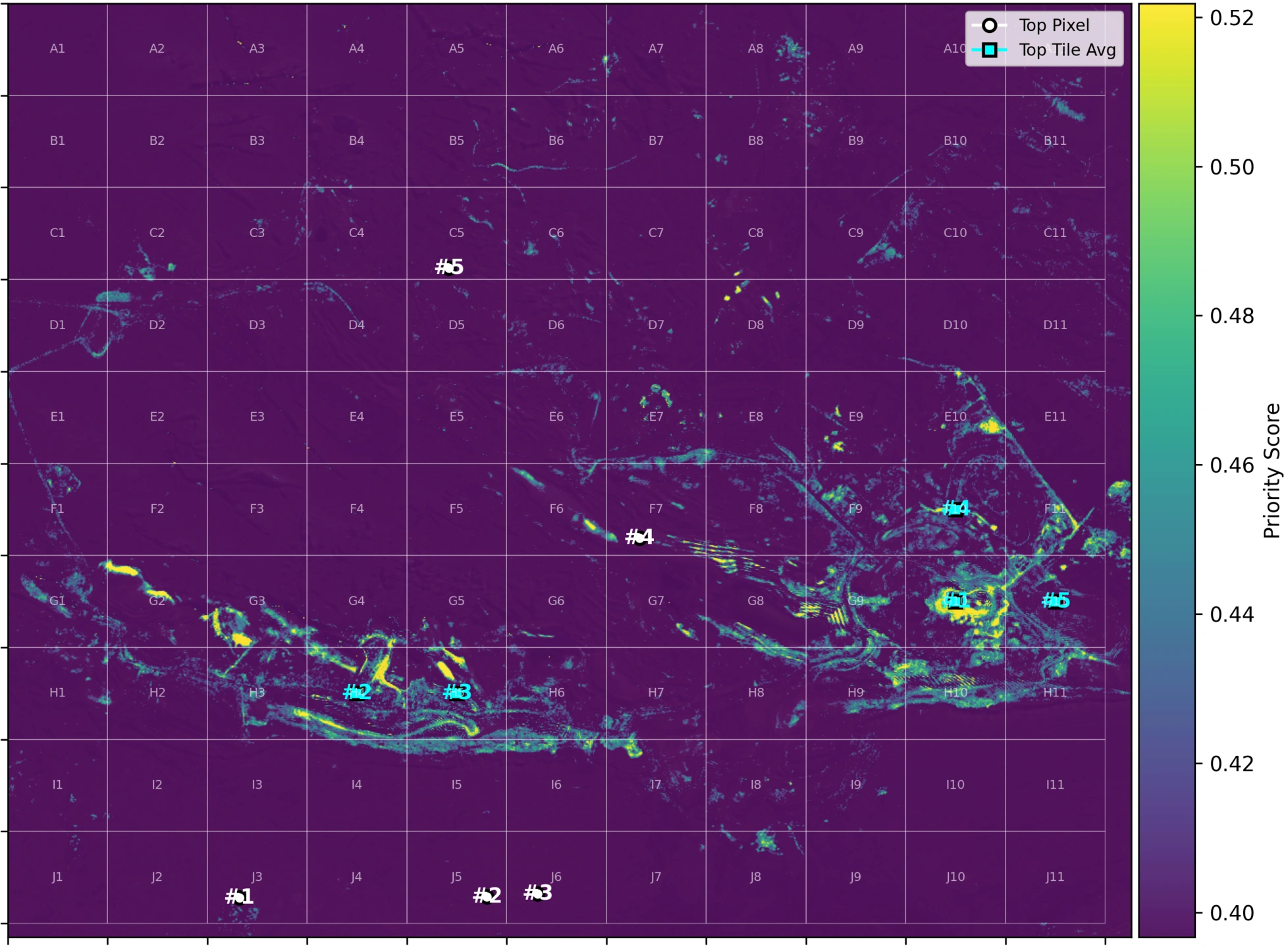
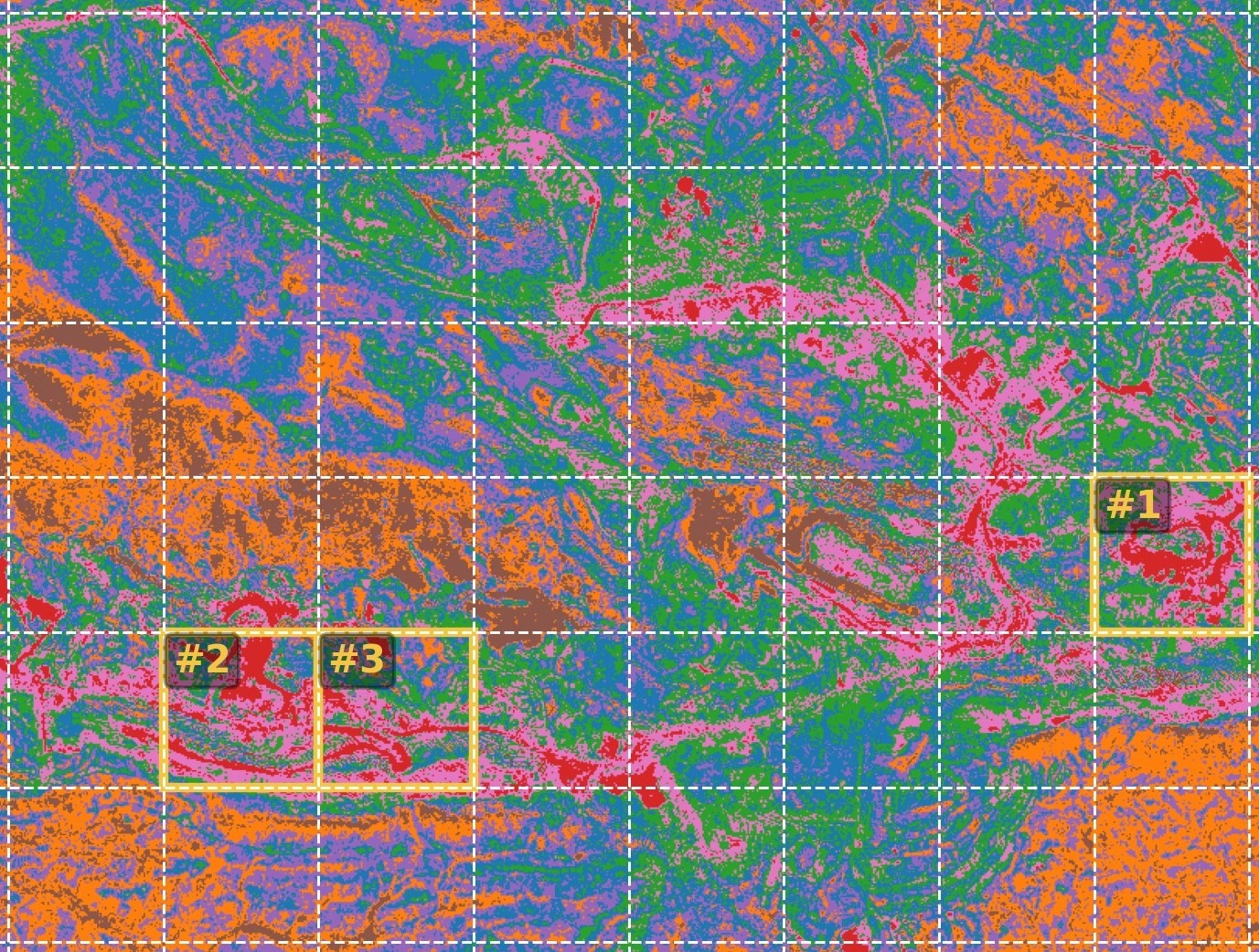
High-Resolution Maps
Publication-quality map figures showing spectral index patterns and priority scoring for rapid visual screening.

Ranked Target Areas
A summary ranking of the highest-priority areas, including location coordinates to support follow-up exploration decision making and planning.
Application & Use Cases

Tenemant-scale screening
Prioritise areas of interest across large land packages to focus follow-up work.

Portfolio evaluation and ranking
Screen and compare multiple prospects or tenements.

Pre-field planning
Guiding field reconnaissance mapping, sampling, or geophysical programs toward higher-priority zones.

Brownfield and near-mine context
Providing surface spectral context alongside existing geological, drilling, or production data.

Early greenfield assessment
Supporting first-pass prioritisation in underexplored areas where existing information is limited and uncertainty is high.
Example Target Mineral Modes
OreScanner supports multiple analysis modes that adjust index weighting and interpretation based on the dominant surface spectral characteristics of interest.

Iron Oxide Targets
Highlights oxidised surface materials and iron-rich spectral responses, including iron-stained lithologies and gossanous surface expressions.

Kaolinite / Al-OH Clays
Prioritises spectral indices sensitive to Al–OH–bearing clays commonly associated with weathered regolith and hydrothermal alteration halos.

Hydrothermal Alteration Zones
Applies a composite weighting to assess spatially coherent surface alteration patterns integrating clay, iron oxide, and silica-sensitive indices.

Heavy Mineral Sands
Emphasises spectral responses associated with surficial sand systems, including variations in iron oxides, silica-rich materials, and vegetation suppression, relevant to coastal, aeolian, and alluvial environments.

Silica Dune Targets
Emphasises silica-dominant surface materials and quartz-rich spectral behaviour, with interpretation dependent on geomorphic and depositional context.

Carbonate / Mg–OH Context
Emphasises spectral responses associated with Mg–OH–bearing minerals and carbonate-rich surface materials, relevant to weathered carbonate sequences and altered ultramafic or sedimentary terrains.
Validation & Technical Notes
OreScanner outputs have been evaluated against known mineralised systems, with results documented in internal validation studies and technical notes. Selected examples are available for review by qualified parties.
Engagement & Pricing
OreScanner studies are scoped per AOI and complexity. Typical early-stage screening engagements range from A$3–5K.
Pilot assessments (with up to a 50% discount rate) are available on a limited basis.
Request an OreScanner Assessment
If you are assessing new ground or narrowing a large exploration area, you can submit an assessment request below. Submissions are reviewed to confirm suitability and scope prior to engagement.